Wet and Hot Central Asia
May 23, 2023
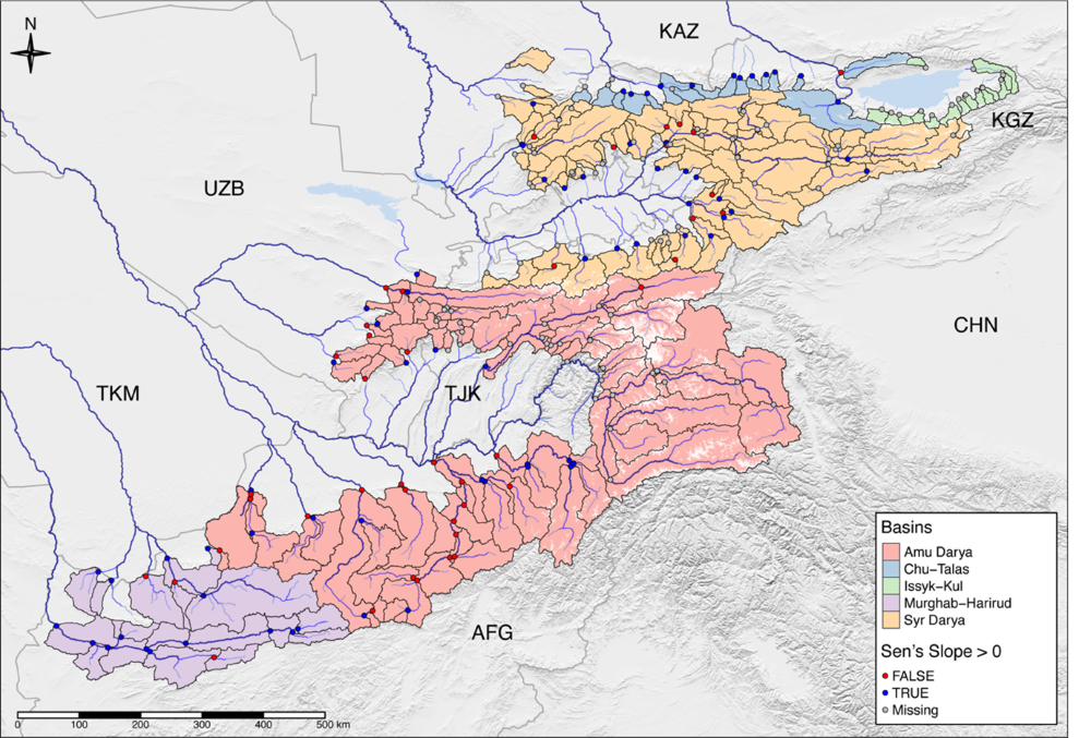
Hydro4U project partner hydrosolutions GmbH has recently submitted a paper manuscript to the open-access Hydrology and Earth System Sciences Journal. In this scientific study, the researchers from hydrosolutions GmbH, jointly with partners from Central Asia, investigated the impact of climate change on the water resources of 221 catchments in high-mountain Central Asia during the 21st century. Figure 1 shows a map of the study region. The highlighted area includes Afghanistan, Kazakhstan, Kyrgyzstan, Tajikistan, Turkmenistan, Uzbekistan and the Hindukush, Gissar-Alay, Pamir, and Tien Shan Mountain ranges.

Figure 1: Map showing semi-arid Central Asia. 221 catchments were delineated and are color-coded according to the larger basin where they are located. They cover an area of 423’099 km2. Where available, long-term historic discharge data shows increasing trends in water supply (blue dots). The red dots show decreasing trends in discharge.
They used a simplified soil moisture water balance model to examine how precipitation gets divided into runoff and evaporation under different climate scenarios. They also compared future periods (2011-2040, 2041-2070, and 2071-2100) to a baseline period (1979-2011) to estimate changes in water discharge across the region and for all catchments using this model.
The researchers used high-resolution historic climate data to obtain daily temperature and precipitation values for each catchment. They also used data from four different climate models (WCRP Coupled Model Intercomparison Project, Phase 6) to predict future climate conditions and compared these predictions to the baseline observed data. To account for variations in soil characteristics, they tested their model’s performance against different soil parameters.
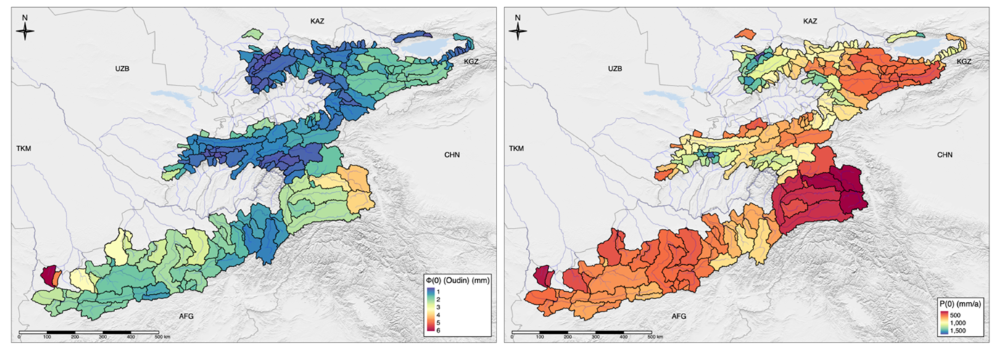
Using the historic climate (Figure 2) and discharge data together with the model, it could be shown that, on average, 42% of the total precipitated water in the mountains runs off to the plains in the downstream where most of it (>> 90%) is consumed in irrigated agriculture. The rest evaporates back to the atmosphere where part of the moisture gets recycled in precipitation.

Figure 2: The left plate shows the aridity index of each catchment and the right plate mean precipitation levels of the baseline period. The aridity index is a measure of dryness.
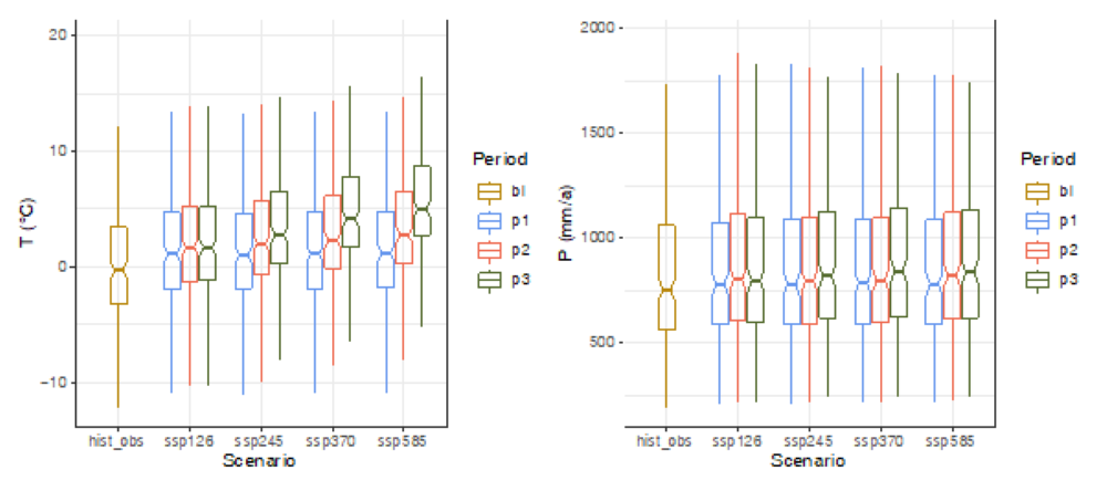
Data from the climate models indicate that Central Asia will likely experience more precipitation and warmer temperatures in the future. The average increase in total precipitation across the catchments and scenarios is 4.44% for 2011-2040, 5.89% for 2041-2070, and 8.51% for 2071-2100. The median increase in temperature relative to the baseline is +1.33°C, +2.44°C, and +3.55°C for each respective period (Figure 3).

Figure 3: Distributions of mean future climate states over all 221 catchments as a function of the climate scenario and the target time period. hist_obs refers to the baseline climate investigated. The remainder scenarios are different climate scenarios with increasing CO2 atmospheric concentrations. Period p1 is from 2011-2040, p2 is from 2041-2070, and p3 is from 2071-2100.
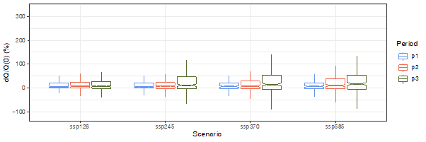
The results suggest that on average water discharge will also increase by 4.71%, 7.44%, and 10.87% in the corresponding periods, despite the potential for increased evaporation (Figure 4). This implies that even though glaciers might contribute less water, the overall water availability in the region will still increase. The most significant changes are expected in the Afghan Murghab-Harirud basin and the Amu Darya.

Figure 4: Per-scenario statistics of relative changes in discharge over the 221 catchments for the three periods. Period p1 is from 2011-2040, p2 is from 2041-2070, and p3 is from 2071-2100.
The study also highlights the need for further research on how these climate changes may impact extreme weather events in Central Asia, as this remains an understudied topic. Overall, the research suggests a warmer and wetter future for the region, with implications for its water resources and hydrological extremes. These are also important in the context of the current and future hydropower developments in the region.
For more information, please visit the preprint online.
Author & picture credits: Tobias Siegfried, hydrosolutions GmbH
